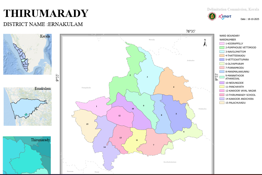
Map
THIRUMARADY GRAMA PANCHAYAT
Final Ward Delimitation Order
15 May 2025
1 Purpose of the Order
Based on the final order issued by the Kerala State Delimitation Commission, Thirumarady Grama Panchayat has been divided into 15 wards. The draft proposals were published on 18.11.2024, and the final notification was issued after considering the complaints and suggestions received from the public.
2 List of Wards and Population
| Ward Number | Ward Name | Population |
|---|---|---|
| 01 | Koorappilly | 1,193 |
| 02 | Pump House Vettimoodu | 1,217 |
| 03 | Navolimattom | 1,108 |
| 04 | Thattekkad | 1,129 |
| 05 | Vettikkattupara | 1,165 |
| 06 | Oliyappuram | 1,129 |
| 07 | Punnamkode | 1,129 |
| 08 | Manimalakkunnu | 1,202 |
| 09 | Aathanikkal Mannathoor | 1,208 |
| 10 | Nedungode | 1,244 |
| 11 | Thirumarady Panchayat | 1,235 |
| 12 | Kakkoor Vayal Nagar | 1,159 |
| 13 | Thirumarady School | 1,156 |
| 14 | Kakkoor Andichira | 1,162 |
| 15 | Palachuvadu | 1,147 |
3 Population Analysis
- Highest population ward: Nedungode (1,244)
- Second highest population ward: Thirumarady Panchayat (1,235)
- Lowest population ward: Navolimattom (1,108)
- The population of all wards ranges approximately between 1,100 and 1,250.
4 Administrative Importance
- Ensures approximately equal population distribution among wards.
- Reduces imbalances in political representation.
- Improves the efficiency of election administration.
- Promotes balanced planning of development projects and distribution of funds.
5 Major Boundary References
- Panchayat boundaries
- Main roads
- Streams and water channels
- Local roads and public institutions
Final Order – Summary
This is the final order issued by the Delimitation Commission with the objective of maintaining an approximately equal population across all 15 wards and ensuring balanced public representation.
6 Thirumarady Grama Panchayat – Ward Delimitation Map
The geographical boundaries and territorial divisions of all 15 wards of Thirumarady Grama Panchayat are shown in the map below.
Thirumarady Grama Panchayat – Ward Boundary Map
Delimitation Commission, Kerala